Image Location Search is a free AI tool that can pinpoint where a photo was taken in the world. It uses advanced artificial intelligence to analyze images and provide precise GPS location data, even when the original EXIF data is missing.
With just a few clicks, you can discover the hidden stories behind your photographs and explore the world through your camera’s lens.
It’s helpful for photographers who want to retrace their steps or share specific locations with others. Travelers can use it to identify landmarks or plan their next adventure. Even businesses can benefit from analyzing the locations of images for market research or content creation.
Features
- AI-Powered Image Geolocation: Analyzes images to pinpoint locations, even without EXIF data.
- Worldwide Coverage: Identifies locations globally.
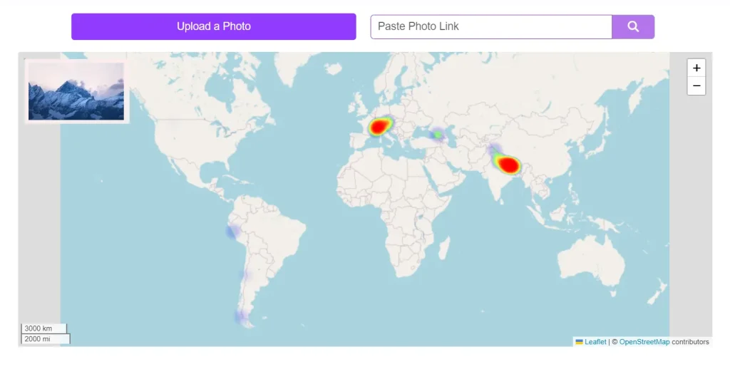
- Interactive Map Interface: Displays potential locations on a map for easy visualization.
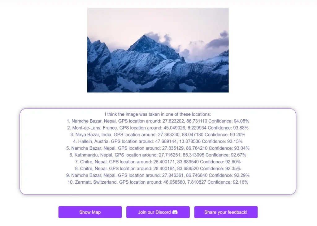
- Confidence Scores: Provides a confidence level for each location prediction.
- Top 100 Results: Offers up to 100 possible locations, increasing the chance of finding the correct spot.
- Search Area Refinement: Allows users to specify a search area on a map to improve accuracy.
- API Access: Provides an open-source API for integration into other applications.
- Offline Model (Enterprise): Offers an offline model for corporate and government clients.
Use Cases
- Travel Planning: Identify landmarks or plan itineraries based on inspiring photos.
- Photo Verification: Confirm the location of images to combat misinformation.
- Historical Research: Discover the locations of old photos with missing information.
- Journalism & Investigations: Verify the location of images used in news reports or investigations.
- Content Creation: Find stunning locations for photography projects or social media content.
How to use it
1. Navigate to the Image Location Search website and upload a photo or paste a link to the image you wish to locate.
2. The AI-powered system will immediately analyze the image and provide the GPS location where the photo was taken.
3. Click the “Show Image” button (requires a free account) to see the spot on Google Maps.
4. For developers who need to integrate the Image Location Search functionality into their own applications, Picarta.ai comes with an open-source API. The API provides access to three key services: Image to GPS, Image EXIF Data, and Landmarks Detection. These services allow developers to quickly incorporate the power of image geolocalization into their projects.

5. For clients who require local processing due to privacy or security concerns, Picarta’s AI model can be installed on private cloud or local servers. This option is primarily designed for corporations and government entities that handle sensitive data. Interested organizations can contact Picarta directly for more information and pricing.
Pros
- Free to use for basic searches.
- Accurate location identification.
- User-friendly interface.
- API access for developers.
- Offline model for enterprise clients.
Cons
- Free tier has usage limits.
Pricing
- Free: 3 searches/day, 100 API calls/month.
- Wallet (€9.9): 100 searches, 200 API calls/month.
- Monthly (€49.9): 1000 searches/month, 1000 API calls/month, then €0.02/image.
- Enterprise: Contact for pricing.
FAQs
Q: How accurate is Picarta AI?
A: Picarta AI boasts a 70% probability of predicting the correct GPS location within its top 100 results.
Q: Can I use Picarta AI commercially?
A: Yes, paid plans offer higher usage limits and API access for commercial use.
Q: What if the image doesn’t have GPS data?
A: Picarta AI analyzes image content to predict locations, even without EXIF data.
Q: How do I access the API?
A: Visit the Picarta AI GitHub page for API documentation and examples.
Q: What is the offline model?
A: The offline model is a deployable version of Picarta AI for enterprise clients needing on-premise or private cloud solutions.
Changelog:
11/04/2024
Updated to V2.
With the release of Picarta V2, the tool’s geolocation capabilities have reached new levels of precision. Picarta V2 achieves a 30.4% accuracy within a 1km range on the IM2GPS3k dataset, a significant benchmark in the geolocation field. Powered by vision transformers (ViTs), Picarta’s AI model leads the industry in reliability and accuracy, with a unique approach that sets it apart from models like ISNs, GeoDecoder, GeoCLIP, and PIGEOTTO. Picarta estimates a 70% probability that its model will locate an outdoor image by examining the top 100 results generated for each input.
See Also
- Guess Where Your Photos Were Taken Using AI – LocGuessr
- Free Photo Geolocation Tool Powered By AI – GeoSpy